
The Cataracts of the Nile: Geography and History
The cataracts of the Nile represent one of the most fascinating geographical features of the ancient world. These rocky rapids and shallow stretches of turbulent water played a crucial role in shaping ancient Egyptian civilization, serving as natural boundaries, defensive barriers, and significant landmarks along the world's longest river.
What is a Cataract in the Nile River?
A cataract in the Nile River is a section where the river's flow is interrupted by rocky outcrops, boulders, and rapids that create shallow, turbulent water. Unlike waterfalls, cataracts are stretches of whitewater rapids where the riverbed becomes elevated with exposed granite and other hard stones. These natural obstacles made navigation extremely difficult or impossible for ancient boats, effectively creating barriers to travel and trade.
The term "cataract" comes from the Greek word "kataraktes," meaning "rushing down" or "waterfall," though true waterfalls are rare along the Nile. Instead, these areas feature cascading water flowing over and around rocky impediments, creating the distinctive churning waters that characterized these strategic locations.
The Six Cataracts of the Nile
Historically, six major cataracts punctuated the Nile River between Aswan in modern-day Egypt and Khartoum in Sudan. Each cataract in ancient Egypt served as a significant geographical marker and often delineated territorial boundaries.
The First Cataract of the Nile River
The First Cataract of the Nile River, located near Aswan in southern Egypt, held immense importance in ancient Egyptian history. This cataract traditionally marked the southern boundary of ancient Egypt proper and served as the gateway between Egypt and Nubia (ancient Kush). The area around the First Cataract became home to the city of Aswan, known in ancient times as Swenett or Syene.
This strategic location made the First Cataract a vital defensive position and commercial center. Valuable materials like granite were quarried nearby, and the region controlled access to precious resources from Africa including gold, ivory, ebony, and incense. The modern Aswan High Dam now submerges much of this historic cataract.
The Second Through Sixth Cataracts
Moving south from Egypt into Sudan, the remaining cataracts created a series of natural obstacles:
The Second Cataract once lay in the region now flooded by Lake Nasser, south of the Egyptian-Sudanese border. In ancient times, this was the site of several massive fortresses built during Egypt's Middle Kingdom to control access to Nubia.
The Third and Fourth Cataracts are located in northern Sudan and were significant barriers to navigation and military campaigns. These cataracts marked the heartland of the ancient Kingdom of Kush.
The Fifth and Sixth Cataracts lie further south along the Nile in Sudan, approaching the confluence of the Blue and White Nile near Khartoum.
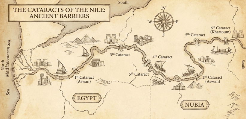
Cataracts of the Nile Map: Understanding the Geography
A cataracts of the Nile map reveals how these six major obstacles created distinct regions along the river. The cataracts essentially divided the Nile into navigable sections, with the stretch between each cataract forming natural zones of control and influence.
From north to south, the cataracts created the following approximate divisions:
- The First Cataract near Aswan marked Egypt's traditional southern frontier
- The Second through Fourth Cataracts ran through Lower Nubia and the Kingdom of Kush's territory
- The Fifth and Sixth Cataracts marked the approach to the Nile's confluence region
This geography meant that ancient civilizations developed in the relatively calm stretches between cataracts, with each cataract region requiring portage—the laborious process of unloading boats and carrying cargo overland to bypass the rapids.
The Role of Cataracts in Ancient Egypt
The cataracts profoundly influenced ancient Egyptian civilization in several ways:
Defensive Barriers: The cataracts served as natural fortifications. The First Cataract, in particular, provided Egypt with a defensive advantage against invasions from the south. Egyptian pharaohs built fortresses at strategic cataract locations to monitor and control movement along the Nile.
Trade and Commerce: While cataracts hindered navigation, they also created important trading posts where goods had to be transferred overland. These portage points became commercial hubs where Egyptian, Nubian, and other African traders exchanged commodities.
Cultural Boundaries: The cataracts often delineated cultural and political boundaries. The region beyond the First Cataract was considered foreign territory, the land of Nubia and Kush, distinct from Egypt proper.
Resource Access: Despite being obstacles, the cataract regions were rich in valuable resources. The granite quarries near the First Cataract supplied stone for temples, obelisks, and statues throughout Egypt. The areas beyond the cataracts held gold mines and access to exotic African goods.
The First Cataract: Egypt's Southern Gateway
The First Cataract of the Nile River deserves special attention for its historical significance. This cataract region includes several islands, most famously Elephantine Island (Abu), which served as a major trading post and military garrison. The ancient Egyptians believed this was where the Nile god Hapy dwelt in caves, releasing the annual flood waters that sustained their civilization.
Egyptian expeditions beyond the First Cataract were major undertakings requiring substantial resources and planning. Pharaohs who successfully campaigned beyond this natural barrier often commemorated their achievements in inscriptions and reliefs. The cataract region also housed important religious sites and became associated with deities connected to the Nile's life-giving waters.
Modern Changes to the Cataracts
Today's Nile looks dramatically different from the river ancient Egyptians knew. The construction of modern dams, particularly the Aswan Low Dam (completed in 1902) and the Aswan High Dam (completed in 1970), has fundamentally altered the First Cataract region. Lake Nasser, the massive reservoir created by the Aswan High Dam, now submerges much of the First and Second Cataracts.
These engineering projects have transformed navigation on the Nile, making the river more consistently navigable but also drowning many archaeological sites and dramatically changing the river's ecology. The seasonal flooding that characterized the Nile for millennia has been regulated, and the cataracts' once-formidable rapids have been tamed by modern technology.
Visiting the Cataract Regions Today
For travelers interested in ancient history, the Aswan region offers the best opportunity to appreciate the significance of the Nile cataracts. While the rapids themselves are largely submerged, the area retains its historical importance and stunning natural beauty. Visitors can explore Elephantine Island, see ancient granite quarries, visit the temples relocated during the dam construction, and cruise on traditional feluccas between the islands where the First Cataract once raged.
The cataracts further south in Sudan remain more difficult to access but offer adventurous travelers a glimpse of the Nile in conditions more similar to ancient times.
Conclusion
The cataracts of the Nile were far more than geographical obstacles—they were defining features that shaped the political, economic, and cultural landscape of ancient Egypt and Nubia. These stretches of turbulent water created natural boundaries, controlled trade routes, and influenced the rise and fall of civilizations along the world's longest river. Understanding what a cataract in the Nile River represents helps us appreciate how geography shaped one of history's greatest civilizations.
From the strategically vital First Cataract of the Nile River at Aswan to the distant Sixth Cataract near Khartoum, these natural features remind us that the forces of nature have always played a crucial role in human history. Though modern dams have transformed these once-wild waters, the legacy of the cataracts continues to echo through the archaeological remains and historical records of the ancient world.
home
